|
Airports
History
Links
skyvector.com
runwayfinder.com FAA AeroNav Simulations: ivao.aero fseconomy.com reddit: r/aviation r/flying r/atc r/flightsim r/shortfinal Donate
|
This page is community maintained. The information is intended for PC simulator navigation or reference.
Always use approved charts for navigation. PHNLHonolulu Intl
Honolulu, Hawaii, United States (96818)
Additional Info / RemarksAttended continuously.
80 and 100 octane fuel avbl thru FBO. Bird strike hazard all runways. See FLIP AP/3 Supplementary arpt information, route and area rstd, and Oakland FIR flt haz. PAEW 600Ј–1300ЈE Rwy 22L and Rwy 22R thld, 1700–0130Z Mon–Fri. Rwys CLOSED 1730–1930Z every month as follows: Rwy 04R–22L first Tue; Rwy 08R–26L second Tue; and Rwy 08L–26R third Tue. Crane 280Ј AGL 300Ј north terminal control concourse until 01 Jan 2009. Rwy 08R–26L 200Ј pavement width with lgts outside, pavement striped 150Ј wide. Thld of Rwy 08L difficult to determine due to Twy T. To minimize foreign object damage potential, all acft should use minimum thrust, especially outboard engines, when taxiing past the F–15 alert facility on Twy Tango. Twy L lights btn gate 50 and gate 59 OTS indef. Twy G lighted sign OTS at Rwy 08L–26R Twy G intersection. Twys G and L between Twy A and Inter–Island ramp clsd to wide–bodied and 4–engine turbo–jet acft under power without PPR from arpt ops manager 808–836–6428 Mon–Fri 1745–0230Z. Tfc pattern overhead altitude 2000(1987), restricted to HIANG acft. Tfc pattern altitude for small acft entering from NW 800(787). Tfc pattern altitude for small acft entering from S 1000(987). Tfc pattern altitude for large acft entering from S 1500(1487). No F–16 transient support avbl in accordance with Area Control Center LSET flash safety 06–02. Transient F–16 units should provide their own maintenance support. PPR all acft units planning to stage ops from Hickam AFB must ctc 15 OSS/OSX DSN 315–449–3129 no later than 3 weeks prior regardless. All military acft rqr Customs/Agriculture/Immigration inspection must ctc Hickam Pilot to Dispatcher or if Air Mobility Command ctc Hickam AMCC, no later than 3 hrs prior to arrival with estimated block time, number of Civilian/Military Passengers/Foreign Nationals/and Distinguished Visitor codes. All transient acft, not on an Air Mobility Command mission, will provide a 2–3 hr out call, as well as 20–30 minute out call on 292.5 to the 15 AW/CP (KOA Control). Upon arrival, crews will proceed directly to Command Post (Bldg 2050) and complete an outbound setup sheet to facilitate departure requirements. No COMSEC material avbl thru Hickam Airfield Ops. Transient aircrews should plan to arrive with appropriate amount of COSMEC to complete entire mission. 613AOC/AMD Coronet Msn Commander will meet acft upon arr, all Coronet W tankers use 311.0 for tanker-fighter inter-plane on launch day. After duty hr DSN 448–8888 613AOC/AMD, Fit Management. Due to non–visibility twr unable to determine if the following areas are clear of obstructions and/or tfc: portions of Twy RB between Twy B and Rwy 08R, portions of inter–island acft parking ramp. Due to location of twr, controllers unable to determine whether acft are on correct final apch to Rwy 04L, Rwy 04R, Rwy 22L and Rwy 22R. Remain at least 1 mile offshore of Waikiki Diamond Head Koko Head and EWA Beach. Arrival Rwy 08L, fly ILS apch procedure or a close–in base leg remaining over center of Pearl Harbor Channel. Arrival Rwy 26L and Rwy 26R, remain at tfc pattern altitudes as long as possible before beginning descent for ldg. All military acft with VIP code 7 or abv ctc 15AB command post or relay thru HF/SSB airway 1 hour out to confirm blocktime. All acft inbd to Hickam should address flt plan to PHIK. All inbound helicopters ctc HIK ramp at fld boundary prior to ldg. Hickam Base Wx station open Mon–Fri 1400Z–0800Z, clsd weekends/holidays except during local flying, as manning permits. Airport Radio Frequencies
[ Edit disabled ]
Runway 08L / 26R
Runway 08R / 26L
Runway 04R / 22L
Runway 04L / 22R
User Notes and Comments
Ad:
Airport Charts[S:2102] 0901Z 02/25/21 - 0901Z 03/25/21 d -TPP
STAR Charts0901Z 02/25/21 - 0901Z 03/25/21 d -TPP
(IAP) Instrument Approach Procedures0901Z 02/25/21 - 0901Z 03/25/21 d -TPP
Departure Procedures0901Z 02/25/21 - 0901Z 03/25/21 d -TPP
|
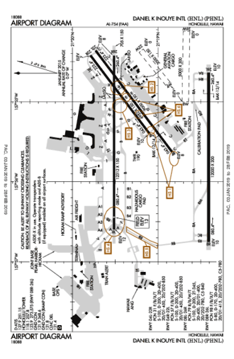
Airport Diagram
Need a New T-Shirt?
Distance To
Nearby Airports
VFR Chart
|
||||||||||||||||||||||||||||||||||||||||||||||||||||||||||||||||||||||||||||||||||||||||||||||||||||||||||||||||||||||||||||||||||||||||||||||||||||||||||||||||
 Australia
 Brazil
 Canada
 France
 Germany
 India
India Italy
Italy Russia
 Spain
Spain UK
UK USA
USA


")
, CONT.1")

")
")
, CONT.1")

")


")
")


 RWY 26L")
 Z RWY 04R")
 Z RWY 08L")
 RWY 04L")
 RWY 08R")
 Y RWY 04R")
 Y RWY 08L")


")
, CONT.1")


")
, CONT.1")

Information on this website may be inaccurate or outdated and is intended for Flight Simulator navigating or for Pre-flight Training purposes only!
© 2018 airportnavfinder.com