|
Airports
History
Links
skyvector.com
runwayfinder.com FAA AeroNav Simulations: ivao.aero fseconomy.com reddit: r/aviation r/flying r/atc r/flightsim r/shortfinal Donate
|
This page is community maintained. The information is intended for PC simulator navigation or reference.
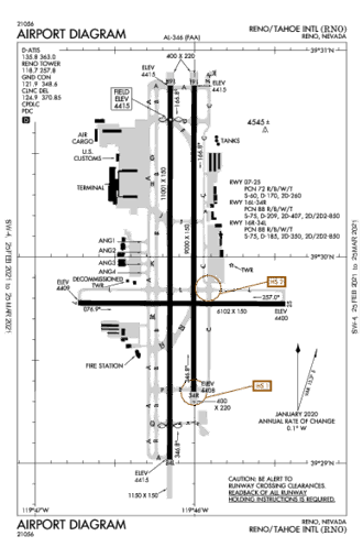
Always use approved charts for navigation. KRNOReno/tahoe Intl
Reno, Nevada, United States (89502)
Airport Radio Frequencies
[ Edit disabled ]
Runway 16R / 34L
Runway 16L / 34R
Runway 07 / 25
User Notes and Comments
Ad:
Airport Charts[S:2102] 0901Z 02/25/21 - 0901Z 03/25/21 d -TPP
STAR Charts0901Z 02/25/21 - 0901Z 03/25/21 d -TPP
(IAP) Instrument Approach Procedures0901Z 02/25/21 - 0901Z 03/25/21 d -TPP
Departure Procedures0901Z 02/25/21 - 0901Z 03/25/21 d -TPP
|
Airport Diagram
Need a New T-Shirt?
Distance To
Nearby Airports
VFR Chart
|
||||||||||||||||||||||||||||||||||||||||||||||||||||||||||||||||||||||||||||||||||||||||||||||||||||||||||||||||||||||||||||||||||
 Australia
 Brazil
 Canada
 France
 Germany
 India
India Italy
Italy Russia
 Spain
Spain UK
UK USA
USA


")
")
")
")
")


")


 Y RWY 16L")
 Y RWY 16R")
 Z RWY 16L")
 Z RWY 16R")
 Z RWY 34L")
 Z RWY 34R")
 X RWY 16L")
 X RWY 16R")
 X RWY 34L")
 X RWY 34R")
 Y RWY 34L")
 Y RWY 34R")


")

")


")

Information on this website may be inaccurate or outdated and is intended for Flight Simulator navigating or for Pre-flight Training purposes only!
© 2018 airportnavfinder.com