|
Airports
History
Links
skyvector.com
runwayfinder.com FAA AeroNav Simulations: ivao.aero fseconomy.com reddit: r/aviation r/flying r/atc r/flightsim r/shortfinal Donate
|
This page is community maintained. The information is intended for PC simulator navigation or reference.
Always use approved charts for navigation. KFSDJoe Foss Field
Sioux Falls, South Dakota, United States (57107)
Airport Radio Frequencies
[ Edit disabled ]
Runway 03 / 21
Runway 15 / 33
Runway 09 / 27
User Notes and Comments
Ad:
Airport Charts[S:2102] 0901Z 02/25/21 - 0901Z 03/25/21 d -TPP
STAR Charts0901Z 02/25/21 - 0901Z 03/25/21 d -TPP
(IAP) Instrument Approach Procedures0901Z 02/25/21 - 0901Z 03/25/21 d -TPP
Departure Procedures0901Z 02/25/21 - 0901Z 03/25/21 d -TPP
|
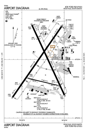
Airport Diagram
Need a New T-Shirt?
Distance To
Nearby Airports
VFR Chart
|
|||||||||||||||||||||||||||||||||||||||||||||||||||||||||||||||||||||||||||||||||||||||||||||||||||||||||||||||||||||||||||||||
 Australia
 Brazil
 Canada
 France
 Germany
 India
India Italy
Italy Russia
 Spain
Spain UK
UK USA
USA


 RWY 03")
 RWY 09")
 RWY 15")
 RWY 21")
 RWY 27")
 RWY 33")


Information on this website may be inaccurate or outdated and is intended for Flight Simulator navigating or for Pre-flight Training purposes only!
© 2018 airportnavfinder.com