Help keep this website running!
Postcard
PayPal
Bitcoin
|
This page is community maintained. The information is intended for PC simulator navigation or reference.
Always use approved charts for navigation.

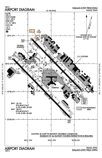
Dallas, Texas, United States (75235)

| Lat/Lng: | 32° 50' 49.6" N / 96° 51' 6.4" W
32.847111 / -96.851778 |
|---|
| Elevation: | 487'ft / 148mMSL |
|---|
| Declination: | E006° |
|---|
| ID / ICAO: | KDAL |
|---|
| FAA: | DAL |
|---|
| Runways: | 3 |
|---|
| Longest: | 13R-31L
Concrete 2,688m / 8,818ft |
|---|
| | |
|---|
| Controlled: | Yes |
|---|
(Edited 2014-05-21) [ Edit disabled ]
| ATIS: | 120.15 |
|---|
| UNICOM: | 122.95 |
|---|
| Clearance Delivery: | 127.9 |
|---|
| Ground: | 121.75 |
|---|
| Tower: | 123.7 |
|---|
| Approach: | 125.2 |
|---|
| Departure: | 125.2 |
|---|
[ Edit disabled ]
| COWBOY VOR-DME | 4.3 NM |
| CVE | freq: 116.20 |
NW 314° |
| MAVERICK VOR-DME | 11.1 NM |
| TTT | 113.10 |
W 277° |
| RANGER VORTAC | 19.2 NM |
| FUZ | 115.70 |
W 278° |
|
| CONIS NDB | 6.7 NM |
| LV | freq: 275 |
SE 138° |
| ISSUE NDB | 10.7 NM |
| PK | 233 |
W 253° |
| REDBIRD NDB | 11.8 NM |
| RBD | 287 |
S 185° |
| JIFFY NDB | 14.6 NM |
| FL | 219 |
NW 314° |
| MESQUITE NDB | 18.9 NM |
| PQF | 248 |
E 97° |
| JECCA NDB | 22.3 NM |
| JUG | 388 |
SE 123° |
| MUFIN NDB | 30.4 NM |
| FT | 365 |
W 275° |
| FLUET NDB | 32.4 NM |
| EF | 421 |
NE 27° |
| TRAVIS NDB | 35.5 NM |
| AVZ | 260 |
E 99° |
| PINCK NDB | 36.1 NM |
| DT | 257 |
NW 326° |
| CADDO MILLS NDB | 37.4 NM |
| MII | 316 |
E 69° |
| CASH NDB | 46.4 NM |
| SYW | 428 |
E 78° |
|
| Dimensions: | 2687.6 x 46m 8818' x 151'ft |
|---|
| Surface: | Concrete |
|---|
| Edge Lights: | High intensity |
|---|
| Runway 13R [A] | Runway 31L [B] |
|---|
| Heading: | 129°MH 135°TH | 309°MH 315°TH |
|---|
Lat:
Lng: | 32° 51' 4.74"N
96° 51' 48.43"W | 32° 50' 2.5"N
96° 50' 36.29"W |
|---|
| ALS: | | MALSR |
|---|
| Dimensions: | 2365.7 x 46m 7761' x 151'ft |
|---|
| Surface: | Concrete |
|---|
| Edge Lights: | High intensity |
|---|
| Runway 13L [A] | Runway 31R [B] |
|---|
| Heading: | 129°MH 135°TH | 309°MH 315°TH |
|---|
Lat:
Lng: | 32° 51' 26.19"N
96° 51' 24.48"W | 32° 50' 31.35"N
96° 50' 20.95"W |
|---|
| ALS: | MALSR | MALSR |
|---|
| TDZ: | | Yes, lighted |
|---|
| Dimensions: | 1882.9 x 46m 6177' x 151'ft |
|---|
| Surface: | Asphalt |
|---|
| Edge Lights: | Medium intensity |
|---|
| Runway 18 [A] | Runway 36 [B] |
|---|
| Heading: | 179°MH 185°TH | 359°MH 005°TH |
|---|
Lat:
Lng: | 32° 51' 31.18"N
96° 51' 11.58"W | 32° 50' 30.65"N
96° 51' 18.53"W |
|---|
| TDZ: | | Yes, lighted |
|---|
BACHMAN EIGHT
 | BACHMAN EIGHT, CONT.1
 | COYOTE TWO
 | COYOTE TWO, CONT.1
 | CURLO FIVE (RNAV)
") | CURLO FIVE (RNAV), CONT.1
, CONT.1") | DALLAS SEVEN
 | DALLAS SEVEN, CONT.1
 | EMMTT FOUR (RNAV)
") | EMMTT FOUR (RNAV), CONT.1
, CONT.1") | ESNYE SIX (RNAV)
") | ESNYE SIX (RNAV), CONT.1
, CONT.1") | GARLAND NINE
 | GARLAND NINE, CONT.1
 | JOE POOL TWO
 | JOE POOL TWO, CONT.1
 | KINGDOM EIGHT
 | KINGDOM EIGHT, CONT.1
 | KKITY FIVE (RNAV)
") | KKITY FIVE (RNAV), CONT.1
, CONT.1") | KRUMM NINE
 | KRUMM NINE, CONT.1
 | KUSSO SEVEN (RNAV)
") | KUSSO SEVEN (RNAV), CONT.1
, CONT.1") | LNDRE FIVE (RNAV)
") | LNDRE FIVE (RNAV), CONT.1
, CONT.1") | LOVE SIX
 | LOVE SIX, CONT.1
 | RAMBL FIVE (RNAV)
") | RAMBL FIVE (RNAV), CONT.1
, CONT.1") | SNSET FOUR (RNAV)
") | SNSET FOUR (RNAV), CONT.1
, CONT.1") | SWABR SEVEN (RNAV)
") | SWABR SEVEN (RNAV), CONT.1
, CONT.1") | SWTSR SIX (RNAV)
") | SWTSR SIX (RNAV), CONT.1
, CONT.1") | TEXOMA NINE
 | TEXOMA NINE, CONT.1
 | TRINITY EIGHT
 | VENUS THREE
 | VENUS THREE, CONT.1
 | WORTH FIVE
 | WORTH FIVE, CONT.1
 |
|
|
 Australia
 Brazil
 Canada
 France
 Germany
 India
India Italy
Italy Russia
 Spain
Spain UK
UK USA
USA


")
, CONT.1")
")
")


")
")
")
")
")
")


")
")
 W RWY 13L")
 W RWY 13R")
 X RWY 13L")
 X RWY 13R")
 Z RWY 31L")
 Z RWY 31R")
 Y RWY 13L")
 Y RWY 13R")
 Y RWY 31L")
 Y RWY 31R")
 Z RWY 13L")
 Z RWY 13R")